You have probably heard that on Febrary 17, 2009, all analog TV stations in the country will stop broadcasting, and analog TV sets will no longer function without a so-called digital converter box. The government is issuing up to two $40 coupons per household that can be used towards the purchase of such converter boxes. These devices sell between $50 to $70 at local retailers. Here is a link to the government’s website where you can sign up for the coupon program.
What you may not have heard is that you don’t have to wait until February 2009 to switch to Digital TV, because stations in the area already broadcast digital channels today. I made the switch yesterday, and I am so impressed with this technology that I decided to share my enthusiasm.
For the past several years I have been using indoor antennas sitting on top of the TV sets to receive the basic local channel lineup, with modest results. The image was often grainy and it was not really a pleasure to watch TV at all, which was fine with me and motivated the kids to do other things – a not entirely unintended side-effect of not signing up for cable or FIOS-service.
I did make the decision to buy a 160 inch outdoor antenna and install it in the attic for the switch to DTV. The house is only 3 years old and wired for cable, so it was an easy task to feed the antenna signal into my home’s cable wiring and get rid of the unsightly indoor antennas (I have yet to work on the proper grounding – yes, even attic-installed antennas need to be grounded).
I purchased this one at Radioshack and it took no more than 30 minutes to assemble it, install it on top of the collar beams, and connect the lead-in cable to the input connector of a splitter that was already present in the attic. Even without using a converter box, the resulting picture is substantially better than it was before. I am not using an antenna amplifier and have 7 cable outlets in the home. I did terminate all unused outlets, though.
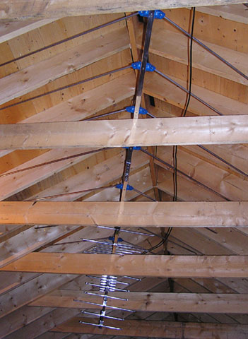
Antenna installed above collar beams
One thing to note is that the correct cable must be connected to the splitter’s input connector – the one that carries the antenna signal. I had to switch the connectors around so that the antenna lead-in is connected to the attic splitter’s “in” connector, and the attic feed is connected to the other splitter’s input in the basement (where normally your cable feed is hooked up).
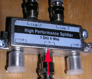
A 4-way antenna splitter
Once the converter boxes were connected and configured, I was blown away by the picture quality and the number of channels that I am now able to receive. Here is the lineup of all channels that I am receiving today:
For a convenient overview of what’s on, I go to tvguide.com.
Some of these channels broadcast in Standard Definition (SD), some in High Definition (HD). Note that with Digital TV there are up to 4 sub-channels for each primary channel. All channels have on-screen programming information.
Digital TV over the air is free, there are more channels than with conventional over-the-air TV, and the picture quality is the same as with cable service – full HD (1080). If you are happy with basic channel line-up, there is no longer a need to pay for cable while still enjoying top-quality picture quality.
The only drawback: If the signal falls below a threshold, there will be dropouts in the audiostream and artefacts in the picture that make it impossible to watch that channel. It is not longer possible to watch channels with poor reception.
One more word of advice: There is no such thing as a digital TV antenna, or even a ‘digital-ready’ antenna. Digital broadcasts use the same transmission technology as analog and are all in the UHF band. Convential TV antennas work perfectly fine, and everybody who claims otherwise is either misinformed or attempting to profit from spreading misinformation.


