Woodcliff Estates discussion draws crowd
By Brandon Todesca/Correspondent
Thursday, January 11, 2007 – Updated: 07:00 AM EST

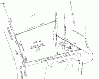
The Planning Board continued the discussion of future development at Woodcliff Estates Monday, drawing a rowdy crowd which filled Town Hall to capacity.
The second floor of Town Hall was packed with developers, neighbors and town officials. The crowd occasionally grew rowdy, shouting comments during the meeting.
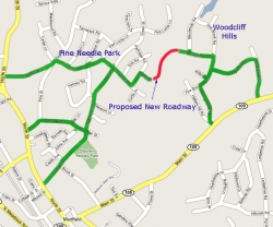
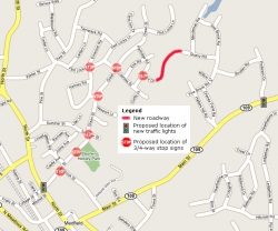
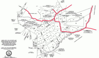
For a number of months, the Planning Board has been examining either the creation of an extended length cul-de-sac, or a cut-through that would ultimately make a connection between North Street and Rte. 109 in the vicinity of Shaw’s Plaza.
“We want to build a cul-de-sac… we’re giving up [housing] lots to put the cul-de-sac plan in,” said Scott Colwell, developer from Colwell Homes. Colwell explained that it had always been his intention to build a cul-de-sac.
Colwell said a cut-through would be an alternative only if the length of the cul-de-sac, which is beyond the town’s 500 ft limit, is not OK’d by the planning board.
John Prego, who lives in the area, asked the board what the spirit of the limit was. Planning Board member George Lester said the limit was intended to ensure two ways out of the area for public safety in case the entrance is blocked.
Included in the evening’s discussion was an alternative route for emergency access through the as-yet undeveloped Erik Road. In previous drafts of the development, emergency access was set to lie on an existing trail between the development and Erik Road.
Fire Chief William Kingsbury said the original path would be too difficult to manage with their bulky fire engines in an emergency. Colwell presented an improved emergency access set at the property lines of two of the housing lots. The alternate emergency entrance would stretch approximately 180 ft, he said.
One concern still held by Kingsbury and the members of the board regarded the actual development of Erik Road, and what emergency access could be available in the meantime. “You can’t approve something that doesn’t go anywhere,” said board member Keith Diggans. Additional research inquiries would be needed, he said, as owners Edward and Bonnie Musto control the Erik Road area.
Town Administrator Mike Sullivan said 4.4 percent of the town’s school children are located in the area. Greg Slowik, whose property is next to the planned development, said the board should take the number of children who are too young for school into consideration as well.
Dickinson was met with few hands when he asked the public if anyone was in support of a cut-through. Maureen Hufnagle, a resident of Brook Street, said she has seen a steady increase in traffic and felt a cut through would cut down on the traffic flow on Brook Street. She said she thinks the board should “value the safety of all of our children.”
A resident of Green Street, Maria Baylor, agreed. She said Brook Street is the only traffic outlet in the area. “It’s fair for the town to consider to take some of the burden off Green and Brook Street,” said Baylor.
When the issue of getting traffic reports for both the cul-de-sac version of the development and the cut through version, the planning board met stern response from Colwell. The developer said the request was not reasonable, as it would cost a large sum of money. Colwell asked the Planning Board to make a decision on a cul-de-sac or cut through, so they could move forward in whatever direction the Planning Board allows.
Dickinson said that with some minor alterations to the designs and some additional paperwork, he thinks the Planning Board could take a vote on the development at their next meeting.
Due to the large crowd that had showed for the meeting, the Planning Board will be holding their next meeting at the High School Auditorium on Feb. 5 at 7:30 p.m.

Here is a link to a January 11 article in the Medfield Press covering the January Planning Board meeting. An earlier article is not available online anymore, so I took the liberty of placing it here in full length. (more…)

The next Planning Board meeting will be on Monday February 5 at 7:30pm at the highschool auditorium. The board has indicated that they are planning to vote on the issue at this meeting.

Concerned Medfield Residents Against a Public Roadway Connecting the Pine Needle Park Neighborhood and Woodcliff Hills

We the undersigned petition the Medfield Planning Board to vote against a proposed public roadway connecting Quarry Road in Woodcliff Hills and Morse Drive in the Pine Needle Park development.

This document is also available for download in the Microsoft Word (256kB) and in the Adobe PDF(196kB) formats.
(more…)

January 12, 2007

Dear neighbor,
I am writing to you in an urgent matter. The town’s Planning Board is currently in the process of conducting hearings about the possible construction of a public roadway connecting Morse Drive in the Pine Needle Park neighborhood (off of Green Street) and Quarry Road in Woodcliff Estates. This road connection would be an attractive shortcut to and from Route 109 for motor vehicles from a large part of Medfield and neighboring towns. (more…)

To subscribe to the mailing list discussing the cut-through between Morse Drive and Quarry Road, please go to:

http://medfieldblogs.net/list

All that’s needed is your email address. Your name is optional. You must register with the email address that you will use to post to the list, or otherwise your postings will not be automatically authorized.

Location of the proposed cut-through (with locations of new stop signs and traffic lights where they will likely be needed)

Location of the proposed cut-through (with locations of new stop signs and traffic lights where they will likely be needed)

The following is a summary of the ongoing discussions at the recent Planning Board meetings about an extension of the Woodcliff Hills subdivision and a new roadway connecting the Pine Needles Park and Woodcliff Hills neighborhoods. (more…)

When we moved into the Green Street area last year, I soon found out about the trail system that starts at the end of Erik Road and ultimately lets me take my kids on a 2-hour walk through Rocky Woods without having to get in the car. We have been taking advantage of this all year round. Obviously, when I recently noticed survey markers in the area off Erik Road for a new development going in, I became concerned about losing access to the trails. I decided to research the details of the project, and what I found is interesting enough to be made available to others. It turned out that my biggest concerns are addressed:

  • The plans for the new subdivision explicitely require that there will be no connecting road between Eric Road and Rt 109 (through the “Woodcliff Hills” subdivision)
  • Trail access to Rocky Woods will be preserved through trail easements and pedestrian easements

Here are all the details. First, I stopped at city hall. While neither the Zoning Board of Appeals nor the Building Department were able to give me any specific information (I was particularly interested in maps that showed any existing easements), I learned that there is quite a history about this new development planned at the end of Erik Road, and that the Planning Board had tried since 1993 to prevent this development from going in, but ultimately lost the case against owners Edward & Bonnie Musto in a 2002 court decision (see below).

Next, I researched the Erik Road Extension development plans at the Norfolk Registry of Deeds web site. Luckily, I found the plan that I was looking for (click on the image at the top of the article for an enlarged view).

Here is a word of caution: In order to view documents on the Registry’s web site, you must install a browser plug-in called BrownTifViewer (an ActiveX control). The intent of the component is to prevent you from saving any document images, taking screen shots using the PrintScreen key, or from printing documents. It contains a keyboard handler that remains active even after you leave the Registry site, and it will therefore mutilate your environment. This can be fixed easily, though – either by uninstalling the BrownTech Image Plugin application from the Control Panel (Add or Remove Programs), or by disabling it temporarily using the Internet Explorer’s Add On Manager.

The map shows that there will be two trail easements at the end of the cul-de-sac that will connect Erik Road Extension to the existing trail system in Woodcliff Hills. This made me very happy.

Since I had been using the trails in Woodcliff Hills for a while, and since I had been concerned about trespassing for a while (some of the trails run very close through the backyards of the mansions in the subdivision), I decided to continue the research and check for easements in Woodcliff Hills, too.

Woodcliff Easement Map

Woodcliff Estates Easement Map

I found this wonderful easement map on the right (click on the image to enlarge the map). It shows that there are indeed easements on all northern lots of Minuteman Road that provide two continuous trails into Rocky Woods. One (easement #12) connects to the trail east of Flint Locke Lane and leads to the Wilson Swamp Trail in Rocky Woods. The other (easement #5) provides access to Cheney Pond Trail and Ridge Trail from lots 32/33 through Minuteman Road, Vine Brook Road, Sturbridge Road and lot 9. All these trails are well-maintained and clearly visible. The easement between lots 32 and 33 consists of a gravel trail that leads from the woods up to the sidewalk on Minuteman road.

Woodcliff Easement Map

Easement on 78 Flint Locke Lane

There was only one thing left to do. There is a section of the trail that runs up behind lot 5 on Flint Locke Lane (extension) and then ends in the backyard of 78 Flint Locke. As the subdivision plan reveals, there is indeed a pedestrian easement on this property. It is not difficult to find. The map shows a 20′ wide strip along the border of lot 6. In the “Inventory of Medfield Trails & Recreational Lands”, a leaflet published by the Friends of Medfield Forest & Trails, I found the following description: Access between #78 and #82 Flintlocke Lane – walk down the hill keeping to the left of the white fence.
This easement allows us to leave our bikes at the end of Erik Road and walk a shorter loop from Erik Road using the trail that leads around the pond up to Flint Locke Lane, then back to Green Street, Partridge Road and Erik Road.

Thank you Planning Board, Map & Trails Subcommittee, and whoever else was responsible for making sure that trail easements are part of the Woodcliff subdivision plans.

For your reference, a trail map of Rocky Woods Reservation is available on the The Trustees of Reservations web site.

Property ownership and assessment information for Medfield is available here.

(more…)


(This is the most recent snapshot)

« Previous Page