Nature and Wildlife


I am organizing a Cache In – Trash Out Event (CITO) for the conservation land behind Ralph Wheelock School in Medfield. If this sounds complicated, fear not. It is a simple cleanup effort that uses the power of GPS devices and the community of geocachers to bring a group of people together at the same time and place. The event is scheduled for 9/26/2010 at 2pm. Bring the entire family, trash bags, a rake, and any other tool you may find helpful. 

Specifically, I want to target the area behind the gravel pit, on top of the hill, that is the location of frequent parties and the site of camp fires and BB gun practices. Unfortunately, the people engaged in these activities do not show much appreciation for the land, and at the end of this summer there is an extensive mess that is too much for one casual dog walker like myself to clean up. I am counting on the support of like-minded Medfielders and geocachers. 

It is difficult not to get upset about this mess, which is entirely unnecessary

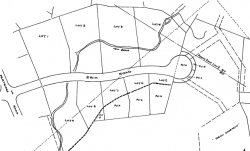
I created a CITO event on geocaching.org that can be used by geocachers to locate the site. It is also very close to an existing cache (A Stop along the Bay Circuit Trail).  Let’s meet at 2pm on Sunday 9/26 (the day after Medfield day) at the site. Parking is available at the Wheelock school, although during soccer games and practice, which is likely to be going on on a September Sunday, it may be necessary to park some distance away from the gate that is the entrance to the soccer fields, but also marks the beginning of the paved trail that leads to the site. 

A 10-15 minute walk from the Wheelock parking lot

The trash consists primarily of bottles, cans, and BB gun artifacts such as CO2 cartridges and millions and millionss of plastic pellets that are strewn all over the area. I am not sure if it will make sense to try cleaning up the latter, since they are so small and there are so many. On the other hand, if left alone, they will soon be covered by leaves, so this is the last opportunity to collect them. I am thinking of using leaf blowers and shovels, but the resulting material will be a mix of soil, wood, and plastic pellets, it will be heavy, and there will be a lot of it – probably too much to be hauled away by volunteers on foot. Let me know if you have a better idea.

Plastic pellets cover the entire area

Link to an article in the Medfield Hometown Weekly

I love to run, even in the winter. I wish I had the time to be out more often. One of the worst things that can happen on a clear and crisp winter morning is having to run by a car that is idling in someone’s driveway. A sharp pain enters my lungs from the exhaust fumes, and I try to breathe as flatly as I can until I am far away.

Why do people install remote starters so that they can start their cars and let them sit in their driveways for 30 minutes or more?

Here is what Consumerreports.com has to say about this practice:

Myth: Let your engine warm up for several minutes before driving.

Reality: That might have been good advice for yesteryear’s cars but is less so today. Modern engines warm up more quickly when they’re driven. And the sooner they warm up, the sooner they reach maximum efficiency and deliver the best fuel economy and performance. But don’t rev the engine high over the first few miles while it’s warming up.

Clearly, this makes sense. But they forgot to finish this thought – if it is better to drive your engine to bring it up to operating temperature, it is worse to not do it. So people who start their car with a remote starter and then let it idle, actually reduce the life expectancy of the car. Think about it this way: The most wear and tear for any engine happens right after it gets started, and the lubricant (oil) is cold and has not reached the proper viscosity that is needed to do its job. The longer the engine runs cold, the more wear it will get. So, start the engine and drive away!

check –  Idling cars in driveways – bad for the cars

European governments have made this practice illegal in the 70s, not because they wanted to help people with extending the life of their cars, but because it is so bad for the environment. Not only do engines do a poor job lubricating themselves when they are cold, they also do a very poor job burning gasoline. The gas does not burn completely, and at no other time does an engine blow more residual substances into the atmosphere than when it is cold.

check –  Idling cars in driveways – bad for the environment

Poisonous exhaust fumes from a neighbor’s driveway can enter garages and homes where children live who then develop asthma or other horrible conditions as a result.

check –  Idling cars in driveways – bad for the health of the neighbors, and bad for neighborly relationships

And finally, if you own a vehicle with a remote starter and actually use this feature to start it up before you step into the shower in the morning, watch out. You might get whacked over the head with a snow shovel by your neighbor who’s kids now have asthma.

check –  Idling cars in driveways – bad for the owner

Will you start your car to let it idle in your driveway this winter?

Our town has a lot of potential for the development of bike paths and trails, but for now there seems to be potential only. I have not heard of or seen evidence of any actual projects. I am particularly interested in the Millis-Medfield-Dover-Needham rail corridor (I believe this is part of what was formerly called the ‘Bay Colony’ line).
Does anybody have information about existing plans or prior initiatives for converting the rail corridor into a multi-use trail? This trail would be a hit. Imagine being able to safely bike to the Needham train station … this would be so much fun with the kids. Having used the Minuteman bike trail in Arlington and Lexington almost daily for some time, I appreciate the recreational value of a multi-use trial.
According to maps on massbikeplan.org, the MBTA has ownership of the Right of Way for this section. The line is desolate, though, and no longer seems to be usable. Particularly the bridge over the Charles no longer seems to be passable, not on foot, let alone for a train. I would actively support and participate in an initiative with the goal to convert the Bay Colony line between Millis and Needham to a bike path. Are there any other supporters? Anybody who can educate me about why this has not already been done?

Realizing that such projects face many obstacles in other communities (see Holliston, for example), I am enough of an idealist to at least educate myself a little bit about the possibility.

When we moved into the Green Street area last year, I soon found out about the trail system that starts at the end of Erik Road and ultimately lets me take my kids on a 2-hour walk through Rocky Woods without having to get in the car. We have been taking advantage of this all year round. Obviously, when I recently noticed survey markers in the area off Erik Road for a new development going in, I became concerned about losing access to the trails. I decided to research the details of the project, and what I found is interesting enough to be made available to others. It turned out that my biggest concerns are addressed:

  • The plans for the new subdivision explicitely require that there will be no connecting road between Eric Road and Rt 109 (through the “Woodcliff Hills” subdivision)
  • Trail access to Rocky Woods will be preserved through trail easements and pedestrian easements

Here are all the details. First, I stopped at city hall. While neither the Zoning Board of Appeals nor the Building Department were able to give me any specific information (I was particularly interested in maps that showed any existing easements), I learned that there is quite a history about this new development planned at the end of Erik Road, and that the Planning Board had tried since 1993 to prevent this development from going in, but ultimately lost the case against owners Edward & Bonnie Musto in a 2002 court decision (see below).

Next, I researched the Erik Road Extension development plans at the Norfolk Registry of Deeds web site. Luckily, I found the plan that I was looking for (click on the image at the top of the article for an enlarged view).

Here is a word of caution: In order to view documents on the Registry’s web site, you must install a browser plug-in called BrownTifViewer (an ActiveX control). The intent of the component is to prevent you from saving any document images, taking screen shots using the PrintScreen key, or from printing documents. It contains a keyboard handler that remains active even after you leave the Registry site, and it will therefore mutilate your environment. This can be fixed easily, though – either by uninstalling the BrownTech Image Plugin application from the Control Panel (Add or Remove Programs), or by disabling it temporarily using the Internet Explorer’s Add On Manager.

The map shows that there will be two trail easements at the end of the cul-de-sac that will connect Erik Road Extension to the existing trail system in Woodcliff Hills. This made me very happy.

Since I had been using the trails in Woodcliff Hills for a while, and since I had been concerned about trespassing for a while (some of the trails run very close through the backyards of the mansions in the subdivision), I decided to continue the research and check for easements in Woodcliff Hills, too.

Woodcliff Easement Map

Woodcliff Estates Easement Map

I found this wonderful easement map on the right (click on the image to enlarge the map). It shows that there are indeed easements on all northern lots of Minuteman Road that provide two continuous trails into Rocky Woods. One (easement #12) connects to the trail east of Flint Locke Lane and leads to the Wilson Swamp Trail in Rocky Woods. The other (easement #5) provides access to Cheney Pond Trail and Ridge Trail from lots 32/33 through Minuteman Road, Vine Brook Road, Sturbridge Road and lot 9. All these trails are well-maintained and clearly visible. The easement between lots 32 and 33 consists of a gravel trail that leads from the woods up to the sidewalk on Minuteman road.

Woodcliff Easement Map

Easement on 78 Flint Locke Lane

There was only one thing left to do. There is a section of the trail that runs up behind lot 5 on Flint Locke Lane (extension) and then ends in the backyard of 78 Flint Locke. As the subdivision plan reveals, there is indeed a pedestrian easement on this property. It is not difficult to find. The map shows a 20′ wide strip along the border of lot 6. In the “Inventory of Medfield Trails & Recreational Lands”, a leaflet published by the Friends of Medfield Forest & Trails, I found the following description: Access between #78 and #82 Flintlocke Lane – walk down the hill keeping to the left of the white fence.
This easement allows us to leave our bikes at the end of Erik Road and walk a shorter loop from Erik Road using the trail that leads around the pond up to Flint Locke Lane, then back to Green Street, Partridge Road and Erik Road.

Thank you Planning Board, Map & Trails Subcommittee, and whoever else was responsible for making sure that trail easements are part of the Woodcliff subdivision plans.

For your reference, a trail map of Rocky Woods Reservation is available on the The Trustees of Reservations web site.

Property ownership and assessment information for Medfield is available here.

(more…)